image

A Five College GIS Day Presentation by

Prof. Robert M. Schwartz

Department of History
Mt. Holyoke College

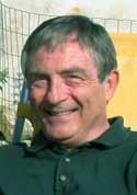
Portrait of Professor Robert M. Schwartz of Mt. Holyoke College.


In his intermediate and advanced courses on the environmental history of Europe, Bob Schwartz introduces GIS to students with no previous background in a six-week unit that investigates the impact of new technology on the human and physical environment. Drawing on his own research, Bob guides students through an examination of railways, population change, and uneven geographic development in Britain and France during the long nineteenth-century (1840-1914).

A map showing the topography of Britain and France.Using subsets of Bob's georeferenced data, students learn the basics of ESRI's ArcGIS to analyze temporal and spatial change. With visualization and statistical techniques, they identify and describe patterns pertaining to a variety of relationships: topography and the evolving route system; the impact of railways on urban landscapes; rail accessibility and net migration; and rail transport and land-use change, such as the shift from arable to dairy farming. Students present their results in a major essay and in an oral presentation. Several of the essays completed last year are now under consideration for publication — proof of student accomplishment and of scholarly interest in historical studies informed by GIS and spatial analysis.

Bob Schwartz is the E. Nevius Rodman Professor of History at Mt. Holyoke College. He has recently secured funding for his GIS-based research through a two-year NEH Collaborative Research Grant.

Wednesday, November 8, 2006, 12:00 Noon

Amherst College, Valentine Hall, Mullins/Faerber Rooms

72° 30' 56" W, 42° 22' 22" N: General directions and maps

Free and open to the public.

Follow the links in the menu on the left to explore the many dimensions of Five College GIS Day.