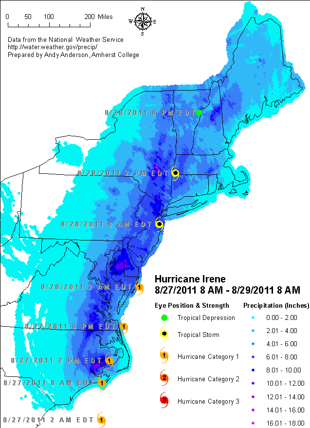
Hurricane Irene, which hit the East Coast of the U.S. over the weekend of August 27 - 28 2011, produced large amounts of flooding in some inland areas such as the state of Vermont (its worst natural disaster since 1927), while leaving other areas such as the Connecticut River valley of Massachusetts relatively unscathed. The Berkshire Mountains of western Massachusetts received between 6 and 8 inches of rain from Irene. In particular, the picturesque town of Shelburne Falls on the Deerfield River, which averages 4.4 inches of rain for the entire month of August, had to be evacuated due to flooding.
There are already lots of maps out there depicting Hurricane Irene and its effects, such as this New York Times map, but many of us would like to play with the data itself. Prompted by a question about local precipitation data, I located downloadable shapefiles from the National Weather Service's Advanced Hydrologic Prediction Service and put it together with storm track information from the National Hurricane Center to produce this map:
Technical Details:
The precipitation data from the National Weather Service is provided as point shapefiles on a 4.3-Km grid (rather than as rasters, possibly because this lets them leave out points with zero precipitation). The files with the shortest time period are for the "hydrologic day", ending at 12 Noon GMT. Two days of data were merged with ArcToolbox > Data Management Tools > General > Merge, and then the precipitation from coincident locations (sharing unique IDs and coordinates) were summed using ArcToolbox > Data Management Tools > Generalization > Dissolve (note that this short-changes North Carolina totals). The hurricane data is provided as a Google Earth KML document, which was converted to a table using GPS Visualizer and imported. The hurricane symbols are built from Character Marker Symbols using ESRI's Climate and Precipitation and Geometric Symbols fonts.
